What the documents say
Residents said these things. Here is what the record says.
In September 2026, at a Marin City Community Services District meeting and in conversations with us, residents raised several things about where the water comes from and what is planned for the pond. Our job is to read the documents, so we did. On the biggest question, whether runoff from Highway 101 drains into Marin City, the county's own stormwater plan says yes, in its own words, with a map. On whether the freeway was designed that way, no document we found says anything.
- Freeway runoff drains into Marin City — the documents confirm it drains here; nothing found on whether it was designed to.
- The tunnel drains into Marin City — the documents don't say.
- The county is blocking the pond's wetland restoration — the records point both ways.
- Marin City wants to become a town — raised repeatedly; no live application found.
- About 6,000 people live here — the Army Corps uses about 3,000; the gap is unexplained.
Each item below carries one of four labels. What each one means.
Nothing here is grading anybody. Someone who has watched water arrive on their street for thirty years knows something a report does not, and the useful thing to do with that is to go and find the paperwork, not to hold the report up against them. Where the documents are silent, this page says so. That is not saying the claim is wrong; it names the office that holds the answer instead.
Partly confirmed
“Highway 101 was built so that runoff from the freeway drains into Marin City.”
The county's own plan says freeway runoff enters Marin City's drains, names three places it happens, and has a project to stop it — but no document says it was designed that way.
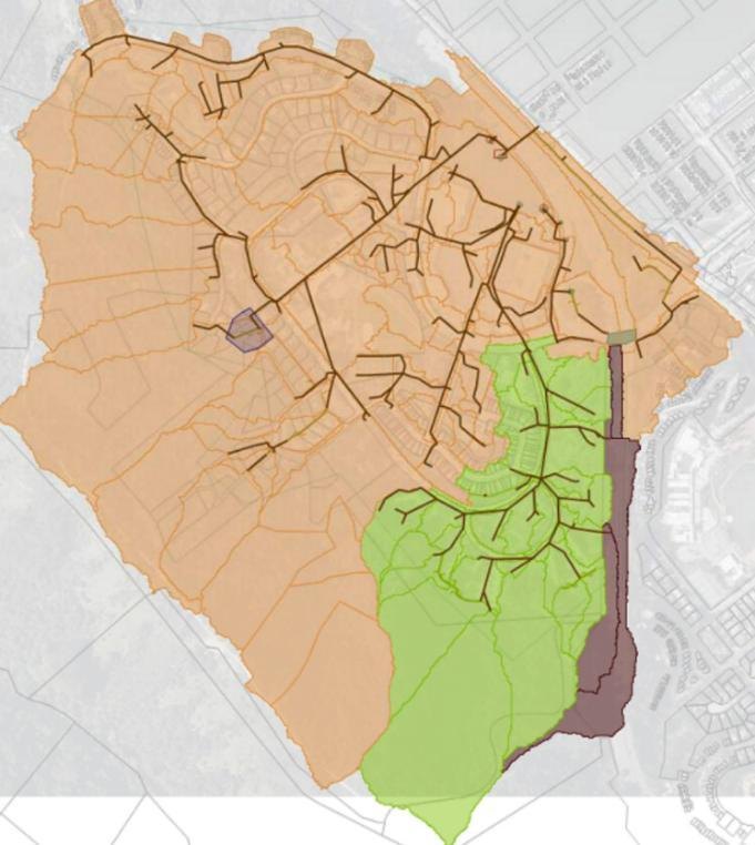
Here the documents answer, and they answer in favor of the person who raised it. The October 2025 stormwater plan has a section called “Reroute Caltrans runoff”, a map of the area involved, and a priced recommendation to disconnect it.
Two things in the plan are worth carrying into a meeting with it, because somebody will raise them. The county calls the volume “not a large amount”; its concern is that when the system clogs, that water runs down the hillside as mud and debris rather than through the pipes.
The plan also describes what happens now, not what anyone intended when the road was built. “It drains here” is documented. “It was designed to drain here” is a different sentence, and no document this project has found supports it.
What the documents say
“There are three locations along Highway 101 on the southbound lane that send runoff into the Marin City storm drain network. The drainage area is shown in brown in Figure 7-16. While the flow generated from Caltrans is not a large amount, disconnecting and rerouting the runoff from the Marin City storm drain system improves drainage. This is because clogging in the system can result in runoff flowing down the hillside, resulting in mud/debris flows.”
Marin City Stormwater Plan, Schaaf & Wheeler for the Marin County Flood Control and Water Conservation District, October 2025, page 88, “Reroute Caltrans runoff”. This project has read this document.
“There are two additional smaller areas that drain the Caltrans right-of-way and the GSC into the Marin City Pond.”
Marin City Stormwater Plan, Schaaf & Wheeler for the Marin County Flood Control and Water Conservation District, October 2025, page 93, describing the lower watershed. This project has read this document.
What would settle it. Ask — the state agency that owns Highway 101 — for the original drainage drawings for the freeway through Marin City. Anyone can request these from Caltrans District 4 under California's Public Records Act; Caltrans' code for this stretch of road is MRN-101. The original construction drawings would show where the drainage was put.
The documents don't say
“The Robin Williams Tunnel — the old Waldo Tunnel — was designed so that its runoff flows into Marin City.”
No document this project can reach mentions the tunnel in connection with Marin City's drainage at all — which is not the same as the claim being wrong.
The 135-page stormwater plan never uses the words Waldo Tunnel or Robin Williams Tunnel. It does discuss Waldo Court, a steep private street at the top of the Eureka Pacheco : a different place, easy to hear as the same one, and worth ruling out first.
What keeps this open: the three places the county documents Caltrans runoff entering the drains are on Highway 101 southbound, the direction climbing the Waldo grade toward the tunnel. Whether any of them is at the tunnel mouth or on the climb above it, the plan does not say and this project cannot tell from here. It is a reasonable question, and an answerable one — just not by anyone reading published documents.
What the documents say
No occurrence of “Waldo Tunnel”, “Robin Williams Tunnel” or any tunnel in connection with Marin City drainage, across all 135 pages. The only “Waldo” is Waldo Court, a private street at the top of the Eureka Pacheco watershed.
Marin City Stormwater Plan, Schaaf & Wheeler for the Marin County Flood Control and Water Conservation District, October 2025, searched in full. This project has read this document.
What would settle it. Ask where the drainage from the tunnel mouths and the Waldo grade lets out, and whether any of the three southbound points in Figure 7-16 is part of it. On paper, a Public Records Act request to Caltrans District 4 for the drainage plans covering MRN-101 from the tunnel down to Marin City would answer it.
The sources disagree
“The county is trying to stop the Marin City Pond being restored to the wetland it used to be.”
A wetland restoration with planning money behind it and a county pump station are both proposed for the same three acres of pond, and both are on the record.
Residents say the second forecloses the first. The Flood Control District says it is working with the people leading the restoration.
The restoration is more than an aspiration: Audubon California leads the Marin City Urban Wetland Community Visioning Project, with the grassroots coalition Shore Up Marin City as partner, and it is funded through the San Francisco Bay Restoration Authority to plan the restoration of the pond into wetland and open water habitat. The proponents' own 2021 fact sheet, saved on this site, says the basin was historically a tidal wetland, and presents the restoration as complementing the county's outfall and tide-gate work rather than replacing it.
The county's proposal for the same water is a pump station moving , a permanent in place of today's temporary barriers, and digging out the mud that has built up in the pond. Its own stormwater plan already describes the pond as “a three-acre tidal marsh habitat” that “functions as a tidal wetland”, and the Flood Control District's project page says it is working closely with Shore Up Marin City and Richardson Bay Audubon on the restoration design.
So the disagreement is not about whether a wetland is desirable, but whether a pump station and floodwall built for flood control can share the site with a restored tidal marsh, or whether building one settles the other. That is a design question with an answer, and it gets answered in the pump station's environmental document: the report the county must publish before building, saying what harm it expects and how it will avoid it. It is public, and this project has not been able to read it.
What the documents say
“The Marin City Pond [is] a three-acre tidal marsh habitat that is a critical component of the storm drain system as it provides detention for stormwater runoff prior to discharging into the Bay.”
Marin City Stormwater Plan, Schaaf & Wheeler for the Marin County Flood Control and Water Conservation District, October 2025, page 32. This project has read this document.
“Most often the sluice gate is left open to allow tidal flushing in and out of the pond, which functions as a tidal wetland.”
Marin City Stormwater Plan, Schaaf & Wheeler for the Marin County Flood Control and Water Conservation District, October 2025, page 93. This project has read this document.
The District's own list of proposed projects for the pond: a portable pump station at Donahue, a permanent pump station and drainage improvements, a permanent floodwall, an environmental pond dredge, and a potential trash capture device.
Marin City Stormwater Plan, Schaaf & Wheeler for the Marin County Flood Control and Water Conservation District, October 2025, page 93. This project has read this document.
The Flood Control District describes itself as working closely with Shore Up Marin City and Richardson Bay Audubon, who are leading a community-driven design process for wetland restoration of the pond, including public access and a park.
Marin County Flood Control District — Marin City Pond Flood Reduction Project, project page. Found by search; this project has not been able to open it.
A community visioning and planning process for restoring a degraded stormwater in Marin City into wetland and open water habitat, with Audubon California as lead and Shore Up Marin City as partner.
San Francisco Bay Restoration Authority — Marin City Urban Wetland Community Visioning Project, project page. Found by search; this project has not been able to open it.
The stormwater basin “was historically a tidal wetland”. The project would “restore 1.6 acres of wetland habitat and create an adjacent park”, is “led by residents of Marin City”, and “will also complement the county's investments to reduce flood risks by increasing the size of outfall structures and installing tide gates”.
Marin City Urban Wetland Revitalization Project fact sheet — Earth Economics, with Shore Up Marin City and Audubon California, 2021, pages 1 and 3, saved copy. This project has read this document.
What would settle it. Ask Shore Up Marin City or Richardson Bay Audubon whether they think the county's pump station design fits their wetland plan. On paper, the answer is in the pump station's environmental document (Marin City Pond Pump Station Flood Reduction Project, state clearinghouse number 2025050759) and any comment letter they filed on it, which would say in the restoration leads' own words whether they consider the design compatible with what they are planning.
Partly confirmed
“Marin City would like to become its own town.”
Becoming a town has been raised repeatedly for at least a decade, but this project found no live application before the county commission that would have to approve it.
The record shows the question keeps coming back: trade press reported in 2014 that the Community Services District thought it worth exploring, local television reported an exploratory committee of residents in 2021, and “Exploring Incorporation” has appeared as a discussion topic at community futures events since.
None of that establishes where it stands now. Incorporation in California runs through a county commission called , which decides where local government boundaries go, and a serious effort leaves a trace there: a notice of intent, an application, a study of whether a town could pay its way. This project found no such trace but cannot rule one out, because it has been unable to reach Marin LAFCO's records. One email would resolve it.
What the documents say
Reported instances of incorporation being explored: the Community Services District considering whether the idea was worth studying (2014); an exploratory committee formed by residents (2021); “Exploring Incorporation and Property Ownership” as a topic at a Marin City futures gathering.
Local and trade press, several reports, none read in full. Found by search; this project has not been able to open it.
What would settle it. Ask Marin LAFCO whether any notice of intent, incorporation application or study of whether a town could pay its way concerning Marin City is currently before the commission, and when the last one was. LAFCO approval is legally required, so its answer is close to settling it. [TODO: project team to confirm how to reach Marin LAFCO, checked by calling.]
The sources disagree
“There are about 6,000 people in Marin City.”
The Army Corps uses about 3,000 people, from the 2020 Census; residents put it at about double, and this project cannot explain the gap.
The agency figure this project has found is the Army Corps' “approximately 3,000”, and it comes from one place: the 2020 Census count for the Marin City census-designated place, the boundary the Census Bureau draws around an unincorporated community.
This matters more than a rounding argument. Population is an input to funding formulas, to the cost-benefit sums in federal studies, and to how serious a road closure sounds when it is described. If the official figure is low, everything computed from it is low.
There are ordinary explanations, and this project cannot choose between them from here. A census-designated place has a drawn boundary, which may not be the one residents mean by “Marin City”. A census count can miss people, though a miss alone would have to be very large to explain a doubling. And a daytime or service population is a different quantity from a residential count.
Until somebody establishes which, this site quotes the Army Corps' “approximately 3,000” where it is describing what the agencies are working from, and says here that residents put it at about double. Neither number is presented as the truth about how many people live here.
What the documents say
The Army Corps' study description gives “approximately 3,000 people”, citing the 2020 Census. [TODO: project team to confirm the 2020 Census count for the Marin City census-designated place from the Census Bureau's own table.]
US Census Bureau 2020, via the US Army Corps of Engineers study description, Marin City CDP. Found by search; this project has not been able to open it.
What would settle it. Compare two maps: the Census Bureau's boundary for Marin City, and the area residents and the treat as Marin City. If they differ, the difference is the answer and it can be measured. The CSD is the body that would know which households it serves.
How this page works
Four labels, and what each one really means
Confirmed in the documents means a document we have opened says so, and the quotation is right there above. Partly confirmed means the documents support some of the claim and are silent on the rest, usually because what the water does today is easy to source and what somebody intended decades ago is not. The sources disagree means two credible records point different ways, and we show you both rather than picking one. The documents don't say means exactly that.
The last label does the most work and is the easiest to misread. It does not mean a resident was wrong. It means we, reading a limited set of published documents with no access to the county's archives, did not find the answer, which exists in an office this page names under “What would settle it”.
If something here is wrong, telling us is worth more than the page being right. Several of these hang on a document we could not open, and a few on where a boundary is drawn. If you know the answer, or you were in the room and this has flattened what was actually said, say so on the bulletin board. We wrote it down so it can be corrected.
The documents themselves are in the studies, the figures pulled out of them are in pictures, and what our own model does and does not know is set out in Sources & limits.