Marin CitySponge Project

Proposals

Marin City's flooding already has plans. Several of them.

The rest of this site could leave you thinking nothing is happening. That is not true. Here are all 9 plans we could find and check, grouped by who is proposing them. Every one belongs to somebody else: its card says what it is, what it would do to the water described in why it floods, where residents stand if they have said, and where to read it. In this site's model there are three switches: that slow the bowl filling, a pump for when the tide holds the gate shut, and a gate that seals properly.

Where do you stand?

Every card weighs its plan from the same eight places to stand. The pros and cons are our reading. The plan as its authors describe it is under “Read more” on each card, with residents' position where they have taken one. Pick a place and the page jumps to that row on the first card and marks it on every card below; pick it again to clear.

Shore Up Marin City and Audubon California

Not an agency: a resident coalition and a conservation nonprofit, funded by the San Francisco Bay Restoration Authority

What residents told this project they want first

Marin City Urban Wetland Community Visioning Project

Makes room for water

Turn the silted pond behind the culvert into a wetland, with a park around it. A design and planning project so far, not construction.

When
No dates published
Cost
Planning funded; no construction figure published

A great blue heron standing on a low strip of green plants at the edge of the pond, its reflection below it in still blue water.
A great blue heron at the edge of the pond. The county's own plan calls the pond “a three-acre tidal marsh habitat”; on a still day, this is what that means. Photograph: the project team, September 5, 2026.

Pros and cons, by where you stand

Where you standForAgainst
You live on the flatTurning the silted basin back into open water and marsh gives the bowl back room it has lost, so in our model water behind the gate has somewhere to go before your corner.It does not touch the gate. When the bay is up, a wetland fills the way the pond does, and the proponents' own figures put flood reduction at a small share of the benefit.
You live up the hillIt pairs with the People's Plan idea of holding silt on the hill. Less mud coming down keeps the basin from refilling.Nothing in it is for the hill streets. Water standing on Cole Drive or in the courts is not this project's subject.
You drive in and outIn the model's larger storms, lower peak levels at the pond mean the Donahue corner and the underpass go under a little later and drain sooner.It is a planning project. No design or date has been published, so it changes nothing about the road until something is built.
You work or shop at the GatewayA park and a path on the lot's edge bring people to the center's door, and the lot's runoff would drain through planted wetland edges instead of straight into a silted basin.The pond is private ground beside the lot. Any change there needs the owner, and the lot itself is not in the plan.
You want the pond to be a placeThe one funded plan that treats the pond as a place: 1.6 acres of wetland, a walking path, viewing piers, and more of the marsh the herons already use.Whether a pump station and a floodwall can share three acres with a marsh is not settled, and the county is designing both for the same corner.
You want Marin City deciding for itselfLed by residents, its own fact sheet says, with Shore Up Marin City at the table, and the plan residents have told us they want first.The planning money came from outside funders, no construction money has been published, and who leads it depends on who is describing it.
You want something done this winterThe planning money is already in hand, so the design can move without waiting on a new grant.No dates, design or construction money have been published, so nothing on the ground is likely to change this winter, and probably not next.
It is your money, or it is notFunded so far by outside restoration money. Residents have not been asked to pay.No construction figure has been published, so nobody can yet say what building it would cost or who pays for it.
Read more: the full description, where residents stand, and this project's reading

Turn the Marin City Pond, the three-acre detention basin behind the culvert, into wetland and open-water habitat, with public access and a park, through a community-driven design process. Who leads it depends on who is describing it. The funder lists Audubon California as lead and Shore Up Marin City as partner. The groups' own 2021 fact sheet, saved on this site, says the project is led by residents of Marin City, with Shore Up Marin City partnering with Audubon California. That fact sheet, the fullest description this project has read, calls the work a restoration and says the basin was historically a tidal wetland. It proposes 1.6 acres of wetland habitat around the basin's edge, with a park beside it: a walking path, viewing piers and exercise stations.

Status
Funded through the San Francisco Bay Restoration Authority for the visioning and planning phase. The 2021 fact sheet names earlier funders: the National Fish and Wildlife Foundation's National Coastal Resilience Fund, the California Ocean Protection Council and the State Coastal Conservancy. It said Marin City would “soon embark” on the work. This project has found no design, schedule or later plan, so there are no dates here. The Flood Control District's pump-station page says the District is working closely with Shore Up Marin City and Richardson Bay Audubon on the restoration design.

Where residents stand: for

Restoring the pond as a wetland is what residents have told this project they want first — ahead of a pump, a wall or a second pipe.

Told to this project by residents, September 2026. The pond's restoration was raised at a Community Services District meeting that month, and residents say it has been reported as a concern at Board of Supervisors meetings. The 2021 fact sheet describes the project as led by residents of Marin City, but ranks nothing. [TODO: project team to name the meeting, letter or statement in which residents ranked the restoration first.]

This project's reading

In the model this is the storage switch, and the one the county's own documents already half-describe: the stormwater plan calls the pond “a three-acre tidal marsh habitat” that “functions as a tidal wetland”. The federal money reported for digging out its silt is aimed at the same three acres. A dredged basin with planted edges gives the bowl back the room it has lost to silt. On its own it does not change the gate. With the bay above the culvert floor, a wetland fills the way a pond does — and the proponents do not claim otherwise. Their own fact sheet values the project at $137,837 a year, $3,126 of it flood reduction, and presents the wetland as complementing the county's outfall and tide-gate work, not replacing it. The open question is whether a pump station and floodwall can share the three acres with a restored marsh; the county's pump-station environmental document is where that would be answered. The People's Plan put dredging and enhancing the basin, and making it a place, third of its six projects in 2018.

Sources

Marin City residents, with the Permaculture and Social Equity Team

Not an agency. A resident cohort working with P+SET for the Resilient by Design Bay Area Challenge, with Shore Up Marin as community partner. P+SET was Pandora Thomas of the Urban Permaculture Institute, Ross Martin Design, Alex Felson of Yale and Ecopolitan Design

The People's Plan for Marin City (2018)

Makes room for water

Residents' own plan from 2018: six priority projects for the neighborhood and three long-horizon ones, including dredging the basin — seven years before the county measured the silt.

When
Published 2018; folded into the county's 2025 plan
Cost
Estimated at a proxy of $20 per square foot of bioretention

Pros and cons, by where you stand

Where you standForAgainst
You live on the flatIt names the Drake and Donahue entrance and the church that floods from storm-drain overflows as first places to work, with catchment where the water actually stands.The county later modeled measures like these and found little flood-control benefit. On the flat they slow the water; they do not keep it off the street.
You live up the hillThe one plan that puts the hill first: brush plugs, check dams and a replanted orchard above Golden Gate Village, to slow the water and cut the silt coming down the gullies.Halfway up, the hill is federal park land. The plan proposes co-managing the watershed with the GGNRA, and this project has found no record of that being agreed.
You drive in and outThe entrance retrofit is aimed at the corner the plan says closes the way in and out of town.It is not a drainage project for the road. Its six priority projects leave the gate, the culvert and the underpass as they are; changing the freeway's height is on its 50-to-100-year list.
You work or shop at the GatewayIt called for dredging the basin behind the lot and making it a park in 2018. The county's drainage study priced desilting the same year; the county measured the silt in 2025.The lot retrofit is a sketch at a proxy price, and nothing this project has read puts the lot's owner behind it.
You want the pond to be a placeDredge it, expand it, put paths and seating around it, and signs that explain the watershed.Dredging the basin is on both of the plan's lists, the priority projects and the 50-to-100-year one, and neither has a date or a budget.
You want Marin City deciding for itselfIts projects were chosen by a resident cohort, with the drawings done at the community's direction, and it states a principle of no displacement.It has no agency and no budget of its own. The county's 2025 plan names it as one of the documents it incorporates, and the county's engineers set the priorities.
You want something done this winterSome of it is small enough to start now: rain gardens, cisterns, a garden at the rec center.Published in 2018, and nothing on its list has a construction date.
It is your money, or it is notCosts were set at a proxy price, pending specifications a contractor could bid on, and none of it asks residents to pay.A proxy of $20 a square foot is not a budget. Every project still has to be priced, and only the pond dredge has money reported, as a county project.
Read more: the full description and this project's reading

A plan produced over three months by an intergenerational resident cohort, through a capacity-building course rather than a consultation. The community determined the projects; P+SET drew the assessment sketches and concept renderings, in the report's words, “at the direction of the community”. It names six priority projects for immediate phasing, and three cross-jurisdictional ones on a 50-to-100-year horizon: modifying the grading and height of the 101 freeway, dredging and enhancing the detention basin at the shopping center, and retrofitting Golden Gate Village. The last is to be “consistent with the People’s Plan for no displacement, appropriate mixed income new development, and historical preservation”.

Status
Published 2018 as the Collaborative Design Phase Final Design Roadmap. Named in the Marin City Stormwater Plan 2025 as one of the documents it incorporates.

The 6 priority projects, as the plan names them

  1. Marin City Intergenerational Garden. The Manzanita Recreation Center as a resiliency hub for the whole of Marin City: water-security cisterns, disaster preparedness, rain gardens and food gardens. The intergenerational garden at its center catalyzes the rest.
  2. Erosion mitigation above Golden Gate Village Building 69. Habitat restoration, creek cleanup, brush plugs in the erosion gullies and small check dams to slow stormwater and cut silt, with a heritage orchard replanted alongside. Halfway up the hill the land becomes GGNRA, the Golden Gate National Recreation Area, which the plan calls an ideal place to begin co-management of the watershed.
  3. Detention basin and adjacent parking lot retrofit. Dredge and expand the basin, and make it a place as well as a piece of drainage: park, pathways, seating, and signage explaining the watershed. The plan notes it has taken silt from the watershed above since it was built and now has greatly reduced capacity.
  4. First Missionary Baptist Church retrofit. The church has flooded from storm drain overflows more than once, and the plan says the drain's design and layout mean it will again. It proposes re-routing overflows around the church with a diversion ditch and receiving bioswale, plus cisterns and a rain garden on the adjacent church-owned home.
  5. Bioswale assemblies along Donahue Street. About 30,000 square feet of open space between Donahue and the baseball field, turned into a small detention basin and bioswale. It would take runoff from the field, the school and other hard surfaces, and link to a run of bioswales along Donahue, including the median.
  6. Resilience retrofit at the entrance to Marin City. At Drake and Donahue, where the plan says flooding is most common and can close the way in and out of town. Golden Gate Village's open space, pathways and parking reconfigured as catchment and detention — visible from the street, and meant to be replicated.

This project's reading

Two things in this document deserve more attention than they have had. The first is an engineering argument, made in 2018 and not obviously answered since. The drainage study of the day looked at the toe of the watershed because flooding of Highway 101 prompted it. Pipe resizing there, the plan says, “would only be temporarily effective until headwaters erosion mitigation work is performed”: fix the pipe, and the hillside refills it. The second is that residents identified the basin as silted and losing capacity in 2018, before the county documented the same physical fact in its 2025 plan. That silting is the reason this site's model passes so little water through the culvert. Most of what this site's own vision page suggests appears here first, in more detail and with a community process behind it.

Caltrans, District 4

California Department of Transportation — owns the highway and the embankment

Marin City Second Culvert Project

Sends some water another way

A new pipe under the freeway, so hillside water from Phillips Drive goes straight to the bay instead of through the pond. Residents have told this project they do not want it.

When
Construction reported for 2027
Cost
$3.47 million, plus $3 million for construction
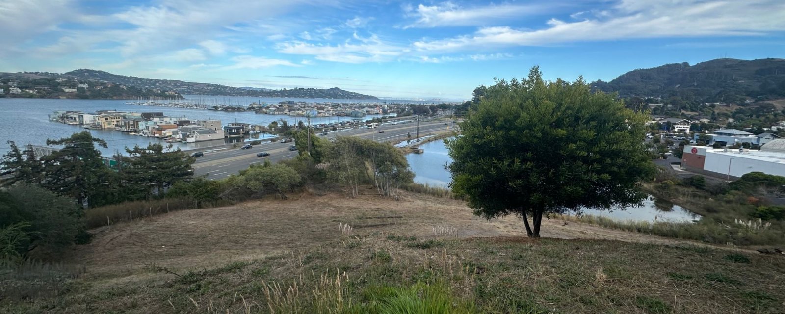
From a grassy hillside, looking down over the pond, the lanes of Highway 101 on their bank, and Richardson Bay beyond with floating homes moored along their docks; Sausalito's hills and a marina in the distance under a streaked blue sky.
The whole mechanism in one frame, from the hillside: the pond at the bottom of the bowl (right of center, below the tree), Highway 101 on its bank, and the floating homes on Richardson Bay across it. Everything the home page tracker draws is in this picture. Photograph: the project team, September 5, 2026.

Pros and cons, by where you stand

Where you standForAgainst
You live on the flatCaltrans' modeling puts the pond's 10-year peak about seven inches lower (7.0 ft NAVD88 instead of 7.6), and the flooded acres at Donahue and 101 at 17.0 instead of 18.7.The pond keeps its one outlet and its manual gate. The corner still floods when a storm lands on a high tide. It floods a little less.
You live up the hillPhillips Drive's hillside water gets its own pipe to the bay instead of sharing the pond's culvert, which is why the pond's peak comes down.Nothing in it is built for the south side of the bowl. Cole Drive and Golden Gate Village drain the same way they do now, toward a pond that peaks a little lower.
You drive in and outIt replaces damaged storm drains at the Donahue interchange and repairs the settled pavement there.The work is at the interchange you drive through: a box driven on piles under the freeway. The environmental document covers traffic during construction; we have not read it for that.
You work or shop at the GatewayLess water arriving at the pond behind the lot means a lower peak against the lot's edge.Nothing changes on the lot itself.
You want the pond to be a placeA lower peak is easier on whatever is planted at the pond's edge.The new outfall lands on the stretch of shore where the floating homes are moored, and the hillside's runoff keeps going to the bay with no wetland on the way, as it does today.
You want Marin City deciding for itselfCaltrans' environmental document took written comments, and residents' objection is on the record if a letter was filed; we have not read the final version to see.Residents have said they do not want it, and it is going ahead. The decision sits with Caltrans and the state, not with Marin City.
You want something done this winterConstruction is reported for 2027, which makes it the nearest built thing on this list with a date, after the portable pump already in place.Not this winter. Construction is reported for 2027, with no month published.
It is your money, or it is not$3.47 million allocated for the culvert, and $3 million more for construction that the Legislature set aside under Assembly Bill 178. Residents are not asked to pay.It is money spent on a plan residents have said they do not want, and it is not available for the one they do.
Read more: the full description, where residents stand, and this project's reading

A bypass, not a second outlet for the pond. Today the 60-inch Phillips Drive drain brings hillside runoff from north of the pond straight into the existing box culvert, which backs water up into the pond. The project reroutes it. About 100 ft of new 60-inch pipe leads into a new 6 ft by 4 ft reinforced concrete box culvert, 195 ft long, driven on piles through Bay Mud under US 101 at post mile 3.65. A new 60-inch pipe then runs under the Bay Trail to a new outfall on Richardson Bay, with a duckbill check valve that shuts against the tide by itself. The project also replaces damaged 18-inch and 12-inch storm drains at the Donahue Street interchange and repairs settled pavement at post mile 3.60.

Status
Environmental review published 2025 (the draft circulated June 2025, the final since published; CEQAnet SCH 2025060164). The idea is older than the project: it appears as costed element LL5, “proposed additional HWY101 culvert”, in the 2018 Marin City Drainage Study.
Funding
$3.47 million allocated for the culvert, with a further $3 million for construction capital from the General Fund under Assembly Bill 178.

Where residents stand: against

Residents have said they do not want this one. Their reason, as told to this project: it would put a second outfall on the stretch of Richardson Bay where the floating homes are moored, carrying the Phillips Drive hillside's runoff into the water those homes sit in.

Told to this project by residents of Marin City, September 2026. Two figures on the pictures page show the geography. The county's stormwater plan (Figure 1-5) shows the channel from the existing outfall running beside a floating-home dock. Caltrans' own project map (Figure 1-3A) puts the new outfall on the same shore, just past the Bay Trail (the Mill Valley–Sausalito Pathway), a few hundred feet along it (post miles 3.60 and 3.65). This project read the draft environmental document for its project description and hydraulic modeling, not for what it says about the floating homes, and has not read the final version or the responses to comments. [TODO: project team to name where the objection was recorded — a comment letter on the environmental document, or a Community Services District meeting.]

This project's reading

Corrected after reading the environmental document: the pond keeps exactly one outlet, with the same manual gate on it. What changes is how much water arrives: the Phillips Drive hillside flow gets its own way to the bay instead of being routed through the pond's own culvert. Caltrans' modeling puts the effect in a 10-year storm at a peak pond level of 7.0 ft NAVD88 instead of 7.6, and 17.0 flooded acres at Donahue and US 101 instead of 18.7. Real, and smaller than “a second way out” sounds. The more interesting detail is the duckbill check valve: the sealing gate this model has as a switch, arriving on the new culvert while the old one stays manual. On the objection: the Phillips Drive flow already reaches Richardson Bay today, through the existing outfall beside the floating homes. The project moves that discharge a few hundred feet along the same shore and puts a valve on it. That is the geography the objection is about; this page reports the objection and does not weigh it.

US-101 / State Route 1 Sea-Level Rise Project, and the Marin 101 Adaptation Planning Feasibility Study

Keeps the bay out

A long-horizon study of how to adapt the US 101 corridor to a higher bay. The only item on the list that treats the bay's level as something that changes.

When
A study; public meetings held in 2024
Cost
Not published

Pros and cons, by where you stand

Where you standForAgainst
You live on the flatThe one plan whose whole subject is a higher bay. If the crossing is rebuilt for one, the gate that shuts on your street is part of what gets rebuilt.A study of the corridor, not of Marin City. No design, date or money for the flat has been published.
You live up the hillIf the crossing were ever rebuilt for a higher bay, the drain through it could be sized afresh for all the water the hill sends down.The hill is where the water comes from, not what this study is about.
You drive in and outIt is about keeping 101 open as the bay rises, and 101 is what Marin City's one way in and out joins.Long horizon. Public meetings in 2024, and no construction planned.
You work or shop at the GatewayThe lot sits on the flat just behind the highway, so whatever is built for the corridor is also what stands between the lot and the bay.Nothing in it for the lot.
You want the pond to be a placeA crossing rebuilt for a higher bay would be a chance to rebuild the outlet and the gate with the pond's future in mind.Sea-level adaptation can also mean a higher wall along the bay side, with the pond still behind it.
You want Marin City deciding for itselfCaltrans held public meetings in 2024, and anything it proposes to build would come back for public comment.The proposal that most affects Marin City while being least about it. Its decisions are made for a corridor, by the state.
You want something done this winterIts value is in what it decides for decades.Nothing this winter.
It is your money, or it is notA state study, with nothing from residents.No cost published, and nothing to build has been proposed yet, let alone paid for.
Read more: the full description and this project's reading

A two-year study developing a long-term sea-level-rise adaptation plan for a segment of the US 101 corridor in Marin County. It builds on the Transportation Authority of Marin's earlier sea-level-rise planning, to identify near- and long-term strategies for the corridor.

This project's reading

Everything else on this list treats the bay's level as fixed and works on the drain. This one does not. If the embankment and its crossing are rebuilt for a higher bay, the sluice gate that shuts when the tide is up is part of what gets rebuilt. That makes this the proposal that most affects Marin City while being least about Marin City.

US Army Corps of Engineers, San Francisco District

Federal engineering agency, with the Marin City Community Services District (the local elected body) as its non-federal sponsor

Marin City Flood Risk Management Study, Section 205

Not chosen yet

A federal study of the whole lower watershed, with the Community Services District as its local sponsor. It has not chosen a plan yet; that is what the study is for.

When
Draft report about December 2027; construction 2031 to 2032, tentative
Cost
$15 million, all federal

Pros and cons, by where you stand

Where you standForAgainst
You live on the flatThe only federal study of the whole lower watershed rather than one pipe, and it can end in federal construction money.It has not chosen anything. Nothing it might build arrives before 2031.
You live up the hillA whole-watershed study can look at the hill's runoff as well as the drain at the bottom.Its brief is floodwater conveyance in the lower watershed, so the hill may be only where the water comes from, not where the work goes.
You drive in and outThe Corps names the one road in and out as part of the problem, in its own description of the place.Whatever it proposes for the road is years away, and every date from 2027 on, the draft report included, is marked tentative.
You work or shop at the GatewayThe pond behind the lot, and its one gate, are named in the Corps' own description of the problem the study is for.A federal plan for the pond would join a county pump and wall and a wetland restoration on the same three acres, with a Caltrans bypass changing how much water reaches them.
You want the pond to be a placeIt has to weigh alternatives, so a restored wetland can be one of them.The Corps says it believes the floodwater carries contaminants: believed, not measured. A wetland would have to answer that, and this project has found no measurement.
You want Marin City deciding for itselfMarin City's own elected body is the sponsor, and a draft report goes to public review around December 2027, where comments on its substance get written answers.The Corps runs the study and writes the recommendation; the sponsor's firm say comes only at the agreement to build, around December 2028, and that date is tentative.
You want something done this winterThe workshops and the public meeting have already started, so the time to shape it is now.Construction, if any, runs 2031 to 2032.
It is your money, or it is not$15 million, all federal, and $0 from Marin City.None of the $15 million touches the ground before the study is done.
Read more: the full description and this project's reading

A federal feasibility study of “alternatives for improving floodwater conveyance in the lower Marin City watershed”, under the Continuing Authorities Program. The Corps describes the watershed as “a bowl turned on its side”, with one road in and out and a privately owned pond, which connects to the bay through a single manually operated tidal gate.

Status
Agreement to start the study signed June 9, 2025; first planning workshop November 13, 2025; public meeting April 2026. A tentatively selected plan is expected around February 2027 and a draft report for public review around December 2027, with construction running February 2031 to September 2032. The Corps labels the dates from 2027 onward tentative.
Funding
The $15 million splits three ways: $700,000 spent on the first look and early feasibility, $2.3 million budgeted for the study to 2028, and $12 million for design and construction.

This project's reading

This is the largest sum on the list by a distance, and the only one where Marin City itself is the sponsor rather than a place things are done to. It is also the slowest: nothing is built before 2031. The two are related. A federal feasibility study is slow by design, and what it buys is that somebody has to look at the whole watershed, not one culvert. For a resident, the date that matters is around December 2027, when a draft report goes out for public review and a federal agency has to answer substantive comments in writing.

Marin County Flood Control and Water Conservation District

County flood authority, working with Marin County Public Works — Zone 3, Richardson Bay

Marin City Pond Flood Reduction Project

Pumps against the tide

A permanent pump station at the pond's corner and a floodwall at its edge, to push water out through the existing pipe when the tide holds the gate shut.

When
Environmental review drafted 2025; no construction date published
Cost
A grant from FEMA, the federal disaster agency, matched by the county's Richardson Bay flood zone; no figure published

Pros and cons, by where you stand

Where you standForAgainst
You live on the flatA pump does not care what the tide is doing. In our model it is the single change that most shortens how long water stands at Drake and Donahue.It does not stop the bowl filling. The street still goes under when a storm lands on a high tide. The water leaves sooner.
You live up the hillWater off the hill drains out of the pond faster afterwards, so the next storm starts from lower down.It is at the bottom of the bowl and does nothing for water standing on the hill streets.
You drive in and outShorter flooding at the corner means the way in and out reopens sooner.It pushes water through the same pipe under the freeway. With the gate shut by the tide it is the only thing moving water, and the documents we have do not say what happens if the power fails.
You work or shop at the GatewayThe station goes at the pond's northeast corner, on the shopping center's own ground, and a permanent floodwall replaces the temporary one along the pond's edge.A pump platform and a wall at the pond's edge are infrastructure, not a park.
You want the pond to be a placePumping lets the pond drain against a high tide instead of waiting hours for the tide to drop, which is what the project is for.A pump station and a floodwall take up part of the three acres the wetland plan wants, and how the two share it is not settled.
You want Marin City deciding for itselfIts draft environmental document went to the state clearinghouse for comment in 2025. The county has to weigh what was filed before it decides; whether that window is still open, we cannot say.Designed by the county's flood district. Residents have told this project they want the wetland first, and the county's plan puts this first.
You want something done this winterIts environmental review is drafted and the county's plan ranks it first, so it is the county's nearest permanent project.No construction date has been published.
It is your money, or it is notA FEMA grant matched by the county's flood zone, with $400,000 of federal money reported toward it. No new charge on residents has been published; what the zone's match costs them, we do not know.No cost for this design has been published; the county's 2018 study priced a pump station only as a drawn element. A pump costs money to run every year, which nothing we have prices.
Read more: the full description and this project's reading

A platform-type pump station at the northeast corner of the Marin City Pond, and a floodwall at the pond's edge. It uses the existing pipe under US 101 to push flood flows to the bay at high tide, when the gravity system cannot drain. The design anticipates adding pumps later.

Status
Draft Initial Study / Mitigated Negative Declaration prepared 2025; listed on CEQAnet as SCH 2025050759.

This project's reading

This is the pump switch in the model, as a real project. The model's 50 cfs figure comes from the county's own stormwater plan, and turning it on is the single change that most shortens how long water stands. It does not stop the bowl filling — it gives the water a way out while the gate is shut, which is precisely the gap the mechanism leaves.

Donahue Street Portable Pump Station

Pumps against the tide

A portable pump at Donahue Street, an interim measure while the permanent station is designed. The nearest thing on this list to help in a storm this winter.

When
In place since 2024
Cost
Not published
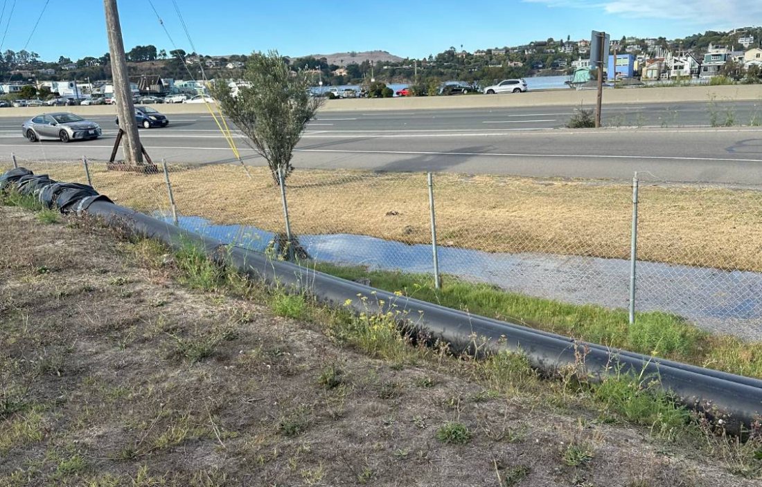
A large black pipe running along the ground beside a chain-link fence at the edge of the pond, with a strip of dry grass, the lanes of Highway 101 and its concrete barrier, and floating homes across the bay beyond.
A black pipe along the fence at the pond's edge, with Highway 101 behind it and the floating homes across the bay; the project team describes it as the county's temporary pumping at the pond. A portable pump went in at Donahue Street in 2024 as an interim measure, and the permanent station is the first project in the county's 2025 plan. The picture cannot say which of those this pipe belongs to. Photograph: the project team, September 5, 2026.

Pros and cons, by where you stand

Where you standForAgainst
You live on the flatThe nearest thing on this list to help this winter: a pump at Donahue Street, ahead of the permanent station.Portable means temporary. We have found no published capacity for it, so nobody can say from the documents how much it shortens a flood.
You live up the hillThe hill's water ends up at the bottom, and a pump there lets it out sooner.Nothing for the hill streets themselves.
You drive in and outIt is on Donahue Street, the one road in and out. Where on the street it sits, the pages we have seen do not say.An interim measure, not a fix for the road. It is there while the permanent station is designed, and we have found no published figure for how much water it can move.
You work or shop at the GatewayIt pumps from Donahue Street, the street the lot fronts, to the culvert at the pond behind the lot.It is a temporary pump and an aboveground pipe, there while the permanent station is designed. Nothing about the lot or how it drains changes.
You want the pond to be a placeIt changes nothing about the pond's ground, so it does not get in the wetland's way.It adds nothing to the pond as a place either.
You want Marin City deciding for itselfIt is the county acting on this winter rather than on a schedule.An interim measure the county chose and announced. Whether anyone in Marin City was asked first is not in anything we have read.
You want something done this winterThe one item on this list meant for now.Interim. It is a stopgap while the permanent station is designed, and nothing we have read says how long it stays.
It is your money, or it is notPut in by the county's flood district, and nothing we have read asks residents to pay for it.Its cost has not been published.
Read more: the full description and this project's reading

It pumps flood water from Donahue Street through an aboveground 24-inch pipe to the existing box culvert.

Status
Installed by the District; Caltrans' environmental document describes it as in place.

This project's reading

Worth separating from the permanent station: a portable pump can be in place for a storm season, where a station takes a construction program.

Marin City Stormwater Plan 2025

Makes room for water

The umbrella study of Marin City's drainage. It measured the culvert and the silted pond, and set out four projects in priority order, the pump station first.

When
Published October 2025
Cost
A study, not a project

Pros and cons, by where you stand

Where you standForAgainst
You live on the flatIt documents the culvert's clear opening and the silt in the pond, and it set a goal: in a 10-year storm at mid-century climate, ponding at the intersections under six inches.A study, not a project. It builds nothing, and its goal is for a 10-year storm, not the worst one.
You live up the hillIt found that over half of Marin City's drain pipes are owned by somebody other than the county, which is the first step to sorting out who fixes what.It found rain gardens and permeable paving do little for flooding here, and less in bigger storms. It recommends them for water quality; none of its four ranked projects is one.
You drive in and outIts four ranked projects are aimed at keeping the way in and out passable.The ranking is the county's, and the longest-term project, a bypass to a new outfall, has no date.
You work or shop at the GatewayIt documents that the pond behind the lot has silted up by about two feet, which is the case for digging it out.It says the pond is on private property, so what happens there is not the county's alone to decide.
You want the pond to be a placeIt calls the pond a three-acre tidal marsh habitat that functions as a tidal wetland, in the county's own words.Its priority list puts a pump station and a wall at the pond before anything green.
You want Marin City deciding for itselfIt incorporates the People's Plan by name, and its issue map carries what residents said at meetings about where things go wrong, alongside the county's own observations.The county's engineers ranked the projects. The plan folds residents' ideas in rather than following them.
You want something done this winterIt is published and final, so it can be quoted at the county today.Nothing on the ground.
It is your money, or it is notPrepared for the county's own flood district, and it gives every later grant application a document to point to.Its projects are costed for the county, and the plan does not say what any of them costs residents.
Read more: the full description and this project's reading

It documents the outlet as a 72 by 38 inch box culvert with a sluice gate. It records that the pond's invert has silted up from about 0.7 ft NAVD88 to around 3 ft. It sets out four projects in priority order: the pond pump station, a Phillips Drive outfall, upsizing the Drake pipe and its inlets, and a longer-term partial bypass to a new bay outfall.

Status
Final report published. It builds on the Marin City Drainage Study (2018), the Southern Marin Watershed Guide (2016) and the People's Plan (2018).

This project's reading

This is the document that corrected this site, not the other way around. Two things here were wrong until it was read: the outlet's dimensions, and calling the sluice gate a self-closing tide gate. Its finding on Low Impact Development is the reason the vision page leads with what sponge measures will not do. Modeled rain gardens and permeable paving showed “little flood control benefit”, and even less in bigger storms.

Transportation Authority of Marin

County transportation agency — here, the body handling the federal money

Federal infrastructure assistance for Marin City

Makes room for water

Up to $10 million in federal money for Marin City's public works, with reported shares for the pump station, a floodwall, and digging the silt out of the pond.

When
Reported September 2024
Cost
Up to $10 million, federal

Pros and cons, by where you stand

Where you standForAgainst
You live on the flat$3 million of it is reported for digging the silt out of the pond, which gives the bowl back storage it has lost.All of it is second-hand reporting. The figures have not been checked with the Transportation Authority.
You live up the hillMoney for the pump, the wall and the silt is money for the bottom of the bowl, where the hill's water ends up.None of the reported shares goes to the hill.
You drive in and outThe pump station and floodwall it is reported to help fund are the county's projects for the corner that closes the way in and out.No dates.
You work or shop at the GatewayOf the three reported shares, digging out the pond behind the lot is the one aimed at the ground itself: the two feet of silt the county's plan records.Dredging a private pond needs its owner, and nothing this project has read says who agreed.
You want the pond to be a placeDredging is what the People's Plan asked for, and the wetland plan calls its work an upgrade to the basin's capacity.A dredge, a pump station and a wall are flood works, not a restoration, and the reported shares fund the wall, not the marsh.
You want Marin City deciding for itselfMarin City was named for this money as a community, on a federal designation.The Transportation Authority of Marin administers it. Marin City holds none of the money, has no seat on the Authority's board, and nothing this project has read says who set the shares.
You want something done this winterReported in September 2024, with three shares already named for the pump, the wall and the silt.Nothing this project has found reports on the money since, and no schedule for spending it.
It is your money, or it is notUp to $10 million, federal, and none of it from residents.$4.15 million of the ten has a reported use. The rest has none we could find.
Read more: the full description and this project's reading

Marin City was selected to receive up to $10 million in federal assistance for public works, under an Infrastructure Investment and Jobs Act program for communities the federal government designates economically disadvantaged. The Transportation Authority of Marin was named to administer and distribute it. Reported allocations are $400,000 to the permanent pump station, $750,000 to a permanent floodwall, and $3 million to removing sediment from the Marin City Pond.

This project's reading

The sediment line is the interesting one. The county records the pond's invert as silted up by about two feet. Money to dig the pond out is aimed at that physical fact and, unlike a pump, gives the bowl back storage it used to have.

Source — not the agency's own