The water has one way out, and the bay decides when it opens
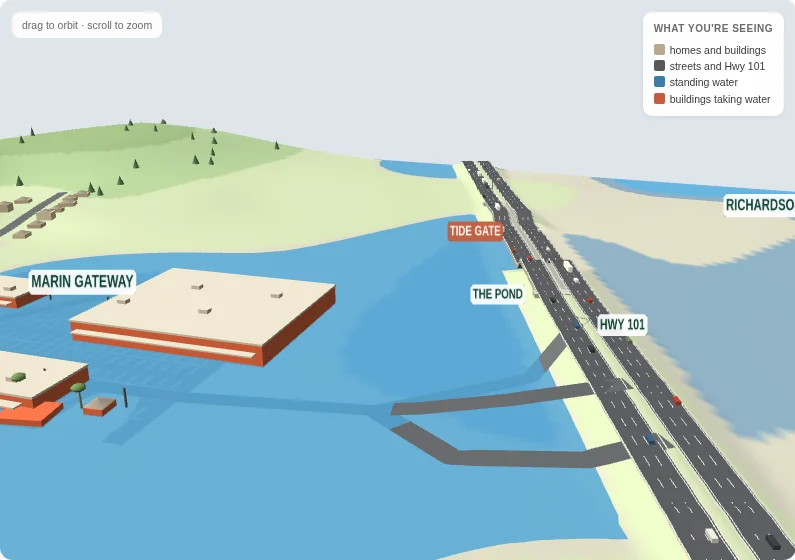
Marin City floods for a reason that fits on one page. Rain lands on roughly 344 acres of hillside and flat, and all of it runs downhill to one low corner, around Drake Avenue and Donahue Street. From there it has one way out: a single (a concrete box) under the Highway 101 embankment, with a on it. While Richardson Bay stands higher than the water behind it, the gate is shut and nothing leaves.
Every number below comes from our own model, measured ground or the agencies' own documents. Where a number is a guess, we say so. Heights are given in feet above the reference level the county uses, with the model's meters in parentheses. The first section is the whole thing in four sentences. Each section after it starts with the plain explanation and carries a block marked The evidence: the measurements and documents it rests on, for anyone who wants to check. The last ends with the part you can do.
01 · The short version
Four sentences carry the whole thing
With these four in your head, you can follow any argument about what to do next, and notice when one of them has been left out. They are also the map of this page: the next three sections take them apart (the bowl; then the culvert and its gate; then the timing), and the last says what would change them.
Marin City sits in a bowl, and roughly 344 acres of hillside and flat drain to the low ground around Drake Avenue and Donahue Street.
The only way out is a single culvert under the Highway 101 embankment.
That culvert has a gate, and the gate is shut whenever Richardson Bay stands higher than the water behind it.
Rain arriving while the gate is shut has nowhere to go, so it stands in the street until the tide falls far enough to let it out.
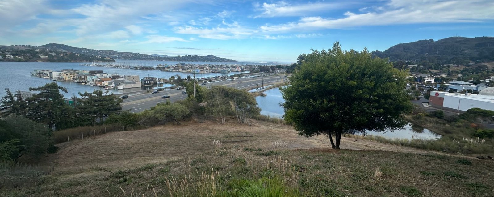
If you live here you know these places. If you do not: Marin City is a small community in Marin County, California, a few miles north of the Golden Gate Bridge. Hills close it in on three sides; on the fourth is Richardson Bay, an arm of San Francisco Bay, with Highway 101 running along the shore on a raised bank. Drake Avenue and Donahue Street meet at the low corner of the flat, beside the Marin Gateway shopping center, at the entrance to town from the highway, and the pond behind the shopping center is where much of the water gathers before it leaves. The photograph below has all of it in one frame.
The whole mechanism in one frame, from the hillside: the pond at the bottom of the bowl (right of center, below the tree), Highway 101 on its bank, and the floating homes on Richardson Bay across it. Everything the home page tracker draws is in this picture. Photograph: the project team, September 5, 2026.
02 · The bowl
A bowl with one drain
Marin City sits in a bowl, and a bowl has no back door. The ground rises on three sides, and on the fourth the Highway 101 embankment stands across the flat. Inside that ring every roof, street, yard and parking lot drains the same way: downhill to the low corner at Drake and Donahue and out through one culvert under the highway. Roughly half of it gathers first in the pond behind the Gateway; the rest reaches the same culvert by a pipe under Phillips Drive, which joins it just below the pond.
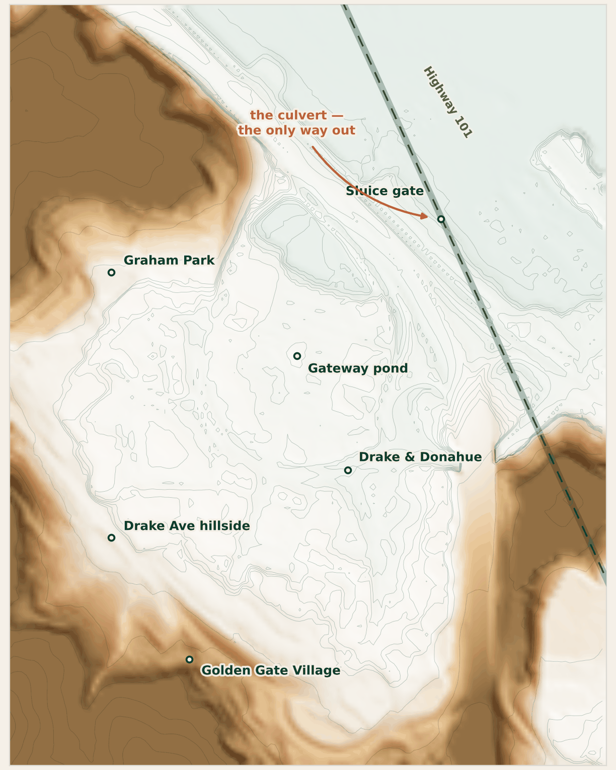
From Golden Gate Village, the long apartment buildings on the hillside, to the bay shore is a drop of about 77 feet, which settles where the water goes.
“A bathtub with only one drain” is how Kristina Hill, who directs the Institute for Urban and Regional Development at UC Berkeley, described Marin City to KQED. It is also the shortest true description of the mechanism: everything runs to one corner, and the corner has one way out.
It is a great deal of water. Roughly 344 acres drain into the bowl: roofs, streets, parking lots, hillside, yards. In the model, about 60% of the rain on that area runs down to the bottom, and the rest soaks in or evaporates. All of it turns up in one corner.
It really is a bowl
The measured ground, lit from the northwest. Nothing here is drawn or traced. The hills close the site on three sides; the one gap in the ring is where Highway 101 runs, and the culvert goes under it. Contour lines are every 1.6 ft (half a meter) on the flat and every 33 ft (10 m) up the hill.
03 · The way out
One culvert under the highway, and a gate the bay holds shut
Highway 101 crosses the flat on a bank of fill. Besides carrying the road, it is the one thing standing between the bowl and the bay: a continuous ridge across the low ground, with one opening where the culvert passes through. The bay does not come over it; the bay simply stands higher than the drain, and while it does, nothing leaves.
The opening is a : a concrete box about six feet wide and just over three feet tall, running under the highway from the pond behind the shopping center, which the county calls the Marin City Pond, out to Richardson Bay. Everything that drains into the bowl leaves through it. The culvert is the hole in the dam.
The culvert has a gate on it: a , a flat gate that slides up and down in a frame, worked by hand, historically by , the state transportation department. Its job is to stop high tides from backing up through the culvert into the pond, and shut, it does most of that job: the bay stays out, apart from a leak we come to below. The gate is the door on the hole.
The cost is written into the same sentence. While the bay is higher than the water in the pond, the gate is shut, and nothing leaves either. Rain falling in those hours has nowhere to go but up, in a bowl whose streets start at about 8 ft (2.5 m).
Most shut hours pass unnoticed, because almost nothing is arriving to be held back. They matter when a storm sits over the , all the ground that drains to the corner, during one of them. That is the next section.
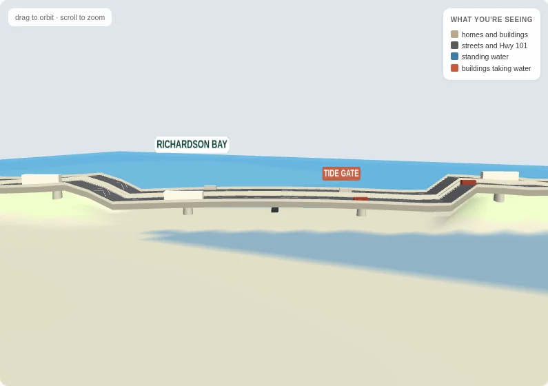
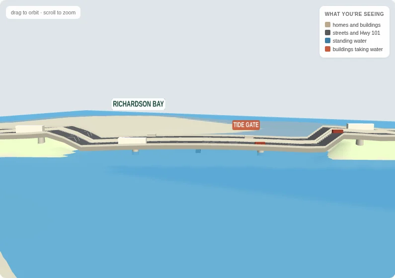
The highway is the wall of the bowl
1 · Normal conditionsThe crossing on an ordinary day: the bay beyond the bank, the flat on the near side dry.
2 · Peak floodThe same view with the bowl full: water held against the inland face of the embankment, the bay on the far side of the same bank.
3 · Down to Donahue StreetThe Highway 101 interchange, the way into town, from above: the Gateway shaded where it is taking water, the pond beside it, and the highway on its way past the gate to the bay.
All three frames are renders from our model, not photographs. The middle one is the point: at peak flood the water in the foreground is the bowl, held against the inland face of the embankment, with Richardson Bay on the far side of the same bank. The ground under it is measured but the water on it is modeled, so read the shape of the water, not the depth at any one address.
04 · When it floods
It floods when heavy rain lands on a high tide
Two things have to line up. Either on its own is manageable.
A big winter storm arriving on ordinary tides is a bad day with an ending. The gate is open for most of it, and the bowl drains down between high tides. A with no rain is a non-event: it is only the ordinary tide at its highest, so the gate is shut for a few hours and almost nothing is arriving to be held back. Only the rarest tides, and only with the gate left open, could reach the corner on their own; the figures are in the evidence under the levers.
Put them on the same afternoon and the arithmetic changes. Runoff arrives at full rate into a bowl with no way out, and keeps arriving for as long as the tide holds the gate shut. The level behind the gate does not have to rise far. Water stands first on the off-ramp from Highway 101 and the low end of Donahue Street, by the Gateway, and the model calls the corner flooded once it rises above the pavement at Drake and Donahue, about 8 ft (2.5 m).
In the model's month, neither ingredient would have done it alone: the same storm is a wet afternoon or a flooded intersection, depending on where in the tide cycle it lands. If you live here, the off-ramp and the low end of Donahue are the spots to watch, and the thing to watch for is heavy rain forecast on a high tide. The front page shows whether the bay stands above the culvert floor right now, the condition that holds shut.
Why cleaning out the culvert is not enough on its own
Clearing a culvert helps. A clearer, bigger opening drains the bowl faster between storms, so each new storm starts from lower down.
But it only helps while the gate is open. In the hours that matter, when a storm arrives on a high tide, the gate is shut, and the size of the pipe behind it makes no difference: a clear culvert and a blocked one drain the same amount through a closed gate, which is none.
That is a statement about how the system works, not a claim about what anyone has or has not done at this culvert. Maintenance is necessary; the point is only that it cannot be enough on its own, because on the worst afternoons the problem is the tide shutting the gate, not how much the pipe can carry.
Which leaves two directions, and one repair. Reduce what arrives during the shut hours by holding the rain where it falls, letting it soak into the ground or pool in a basin up the hill before it reaches the low streets. That is what we mean by , the idea in the site's name: ground and streets built to soak up rain and hold it back, instead of sending it all downhill to one drain at once. Or pump what arrives over the gate, whatever the tide is doing. And make the gate seal, so the bay stops coming in through it while it is shut. The model has a switch for each; they are next.
05 · What would change it
Three things that would change it, and what we still need to know
Beyond the size of the storm, the model has three switches, each attacking the problem at a different point: the water arriving, the water leaving, and the water coming back in through the wrong end. The first, the of the site's name, is the subject of What is a sponge?, where six places that built them are drawn before and after.
01 · The water arriving
13% less runoff
0.60 →falling to 0.52, and about 1.2 million gallons held back
Sponge measures across the whole hillside and flat
Soaking rain into the ground () lowers the share of rainfall that reaches the bowl at all, about 13 percent less runoff from the same storm. Holding it in basins up the hill () holds back up to about 1.2 million gallons (4,500 m³) before it reaches the streets.
In the model the held-back water is a tank that takes in up to about half the runoff while it has room and drains out over about an hour of dry weather, so it is empty again well before the next storm. What it lets out is not sent back into the bowl, which flatters this lever a little. Sources & limits explains that simplification.
02 · The water leaving
50
about 22,000 gallons a minute (1.4 m³/s) lifted over the gate
A pump station at the outlet
A pump does not care what the tide is doing. It lifts water from behind the gate to the bay side while the gate is shut, which is exactly the window when nothing else is working.
In the model it starts once the water behind the gate stands at about 5 ft (1.6 m) on this page's scale, which is roughly 2 ft (0.6 m) above mean sea level, and adds a flat 22,000 gallons a minute (1.4 m³/s) to whatever the culvert is managing. That is well under what the culvert itself passes once the water behind it stands about 3 ft (1 m) higher than the bay, so with the gate open the pump is a supplement, and with it shut the pump is the whole outlet.
03 · The water coming back
Sealed
nothing leaks back in while it is shut
A sluice gate that closes tight
A gate that does not seal lets the bay push in through the structure while it is closed. That fills the bowl from the wrong end, on exactly the tide when the bowl has no way to empty.
In the model an unsealed gate leaks backward at about 18 percent of the rate it would let water out with the same difference in level across it. Sealing it sets that to zero.
Try the three levers
This is the same picture as the front page, in a storm at high tide with the gate shut. Switch each measure on and watch what it does to the water in the street — and read what it does not do, which matters just as much.
Switch one on. Each says what it does, and what it does not.
Schematic, and the depths are illustrative — three switches at once is not a dry street, and the drawing does not pretend otherwise. The numbers are on the 3D model.
What each lever touches, and what it cannot
Read across each row: one lever works on the water arriving, one on the water leaving, and one on a loss that only exists if the gate does not seal. They are not substitutes for each other.
What each modeled lever works on, and what it leaves alone
Lever
What it works on
What it leaves alone
Sponge measures
The volume of runoff arriving in the bowl, and how quickly it gets there.
The size of the way out. A smaller peak still has to leave through the same opening (a 72 by 38 inch box, about 19 square feet), past the same gate, on the tide's timetable.
A pump station
The rate at which water can leave while the gate is shut.
The volume arriving. A pump running flat out still has the whole hillside draining toward it.
A gate that seals
Bay water pushing in through the structure while it is closed.
Everything arriving from above. It removes a loss rather than adding capacity.
What it would take to know, and the part you can do
The model can say which lever moves the water. It cannot say how big to make anything, and it would be dishonest to pretend otherwise. Sizing sponge measures, a pump or a replacement gate is an engineering job, and it begins with three measured things we do not yet have. If you live here, the first of them is yours to supply; if you are reading from another low town behind a tide gate, they are the three to ask for there.
Depths, measured. If you live here, this is the part you can supply. A photo of water on your street, with the time on it, becomes a depth in the photo tool. Ten or fifteen of those across one winter, each paired with the bay level at that minute, would let the model be fitted to this street rather than assumed.
What the gate is doing during a storm. The culvert itself is not the soft spot: the model uses the 72 by 38 inch clear opening the county reports (about 19 square feet), which matches the flows published in Caltrans's own environmental document. What is not settled is the gate. The county documents a sluice gate worked by hand, not a self-closing tide gate, and the only record of anyone working it is one winter's log: twenty closures between December 2015 and March 2016, and in the four December days that overlap the bay gauge record, every reopening was logged at twenty inches, well under the full height. Every lever above is scaled against a gate whose real position on a given day nobody publishes.
What the ground will absorb. The elevations are measured now, by federal in NAVD88, so the shape of the bowl is settled; what it is made of is not. That 1.2 million gallons (4,500 m³) of detention has to fit somewhere real, on ground that will take it. [TODO: project team to confirm soil and infiltration data for the catchment — what the ground can absorb, and where there is land with the depth to hold water back.]
Until those exist, this page is an explanation of how the flooding works, not a recommendation. That is the smaller claim, and it is the one that holds up.
The idea behind the first lever, and six places that built it, are on the What is a sponge? page. The limits of all of this (what is measured, what is estimated, what is an assumption chosen to fit) are written down in Sources & limits.