This 40-year timeline tracks what has been done since 1992 and what is scheduled through 2032, every row in date order, with a link to the source wherever there is one.
Of these 28, 20 have already happened. Tap an agency's name to see only what it has done and what it is scheduled to do.
The list opens before the first study, with a prologue from 1926 on how there came to be a neighborhood at the bottom of this particular bowl. That question has a documented answer, and the answer changes what the rest of the list means. Those rows are not counted above, because they are not work on the flooding.
How Marin City got here
1926–1968 · 5 entries
1926–1968Past
How it began
Racially restrictive covenants across Marin
Property deeds, recorded by Marin County
Clauses written into property deeds across the county barred people of color from buying, leasing or occupying the land. Marin County now runs a Restrictive Covenant Project, through its Assessor-Recorder, Community Development Agency and Office of Equity, to find and record them, and dates their enforcement roughly from 1926 to 1968. After the Federal Housing Administration was created in 1934 they became standard practice: federal loan guarantees went to developers of whites-only subdivisions. The source is the county's own record of the covenants.
After Pearl Harbor the Maritime Commission needed ships, and Bechtel built Marinship on the Sausalito waterfront to make them. A shipyard that size needs somewhere for its workers to sleep, so the federal government put up housing for around six thousand of them on the flat valley floor immediately inland. That housing was Marin City: built quickly, meant to be temporary, and racially integrated — rare enough in 1942 to be described at the time as an experiment.
Recruiters went out across the South, the Midwest and the Southwest. Black workers came from Louisiana, Arkansas, Mississippi and Texas to jobs paying in an hour what the same hands earned in a day at home, in industries that had been closed to them. The shipyard's welcome, as the San Francisco Chronicle put it looking back, ended at the gates.
The yard closes. Some people can leave, and some cannot
Marinship
The war ended and Marinship shut. Most of the white workers left with wages in their pockets and bought elsewhere in Marin, which was building subdivisions on the hills and the higher flats. Black workers had the same wages and nowhere to spend them: buying outside Marin City was closed to them and renting outside it close to impossible. So the temporary housing was not temporary, and the community that stayed in it stayed on the valley floor.
The wartime housing was replaced with something permanent: 296 homes designed by Aaron Green, who trained with Frank Lloyd Wright, with the landscape by Lawrence Halprin. It is the county's oldest and largest public housing, it won a federal First Honor design award in 1964, and on September 18, 2017 it was added to the National Register of Historic Places. It sits on the bench above the flat, the highest of the places this project gives an elevation for.
Cited in the People's Plan as one of the documents its research drew on. The oldest planning document on this list, and the only one this project has not been able to find a copy of.
This project has not read the underlying document.
July 31, 2012Done
Community
The district board is to decide whether to study incorporation
Marin City Community Services District, as reported by the Marin IJ
The Marin IJ reported that the district board would meet that Thursday to decide whether to form a committee to study whether Marin City could become Marin's twelfth city, with its own council and mayor. The district's director said nobody had “put the legwork into it to see if it is feasible”. The money named was sales tax from the Gateway Shopping Center and possible redevelopment revenue; a late-2004 study had put Marin City's combined property and sales taxes at $7.6 million a year, some of which could run a city (a line read from beneath the newspaper's banner in the saved copy). This project does not know whether the committee formed, or what it found.
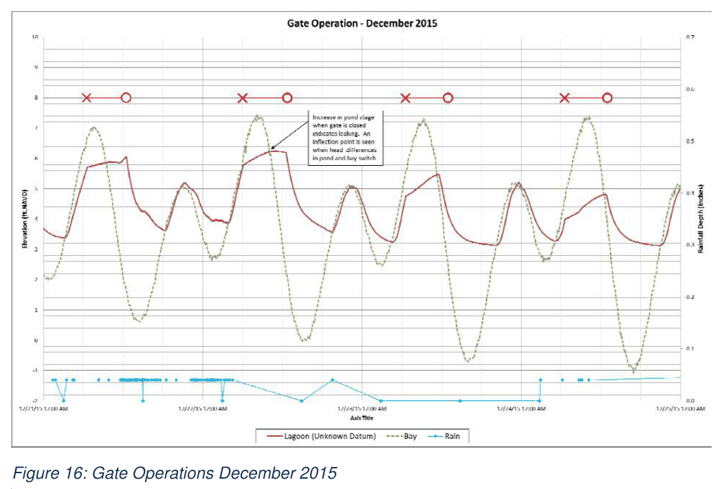
317 pages. Existing conditions flood 16.4 acres in a 10-year storm and 43.7 in a 100-year. Four costed alternatives, and six individual elements — a culvert inlet flap gate, desilting the basin, a floodwall, a pump station, an additional Highway 101 culvert, and a Caltrans detention basin. Almost everything built or funded since appears here first.
Figure 16 · Marin City Drainage Study, p. 27Source ↗
2018Done
Community
The People's Plan
Marin City residents, with the Permaculture and Social Equity Team and Shore Up Marin
Six priority projects determined by residents, through a three-month capacity-building course rather than a consultation. It names the silted basin seven years before the county documents it, and argues that pipe work at the toe of the watershed only holds until the hillside above refills it.
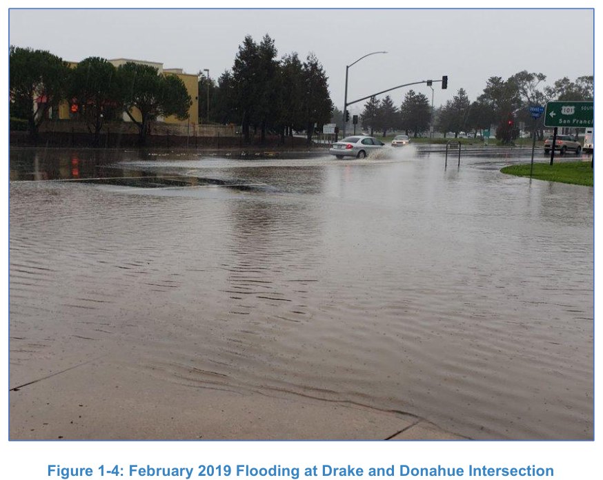
Photographed and captioned in the county's own stormwater plan as Figure 1-4, six years before the plan was published. It is the corner this whole site is about, and the picture is the county's evidence that it floods.
Figure 1-4 · Marin City Stormwater Plan, p. 4Source ↗
2021Past
Flood
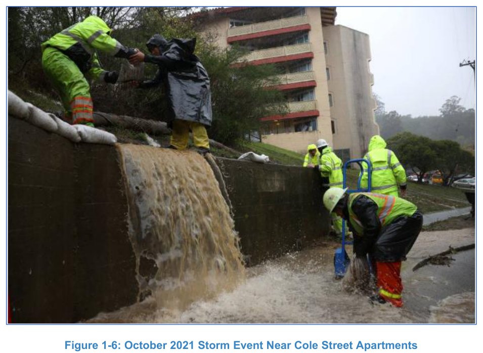
A storm closes the only road again
—
The Army Corps records the same thing happening in 2021. Caltrans counts three closures of southbound US 101 and the Marin City entrance since October 2014.
Figure 1-6 · Marin City Stormwater Plan, p. 6Source ↗
2021Done
Community
The wetland plan for the pond, on paper
Earth Economics, with Shore Up Marin City and Audubon California
A four-page fact sheet for the Marin City Urban Wetland Revitalization Project: restore 1.6 acres of wetland habitat around the edge of the stormwater basin (historically a tidal wetland, the sheet says) and build a park beside it with a walking path, viewing piers and exercise stations. The sheet describes the project as led by Marin City residents and funded by the National Fish and Wildlife Foundation, the California Ocean Protection Council and the State Coastal Conservancy. It values the benefits at about $140,000 a year, $3,126 of it flood reduction, and presents the wetland as complementing the county's outfall and tide-gate work, not replacing it. The link is this site's saved copy; the address it was published at has not been located.
Includes $2.8 million to replant 15 acres of eelgrass in Richardson Bay over four years — the water the bowl drains into. See the “Downstream” section of What could be here.
An interim measure while the permanent station is designed: it pumps flood water through an aboveground 24-inch pipe to the existing box culvert at the pond. Caltrans' environmental document describes it as in place.
Up to $10 million of federal infrastructure assistance
Transportation Authority of Marin, administering
Marin City selected under a federal program for communities the government designates economically disadvantaged. Reported allocations: $400,000 to the permanent pump station, $750,000 to a permanent floodwall, and $3 million to removing sediment from the pond.
This project has not read the underlying document.
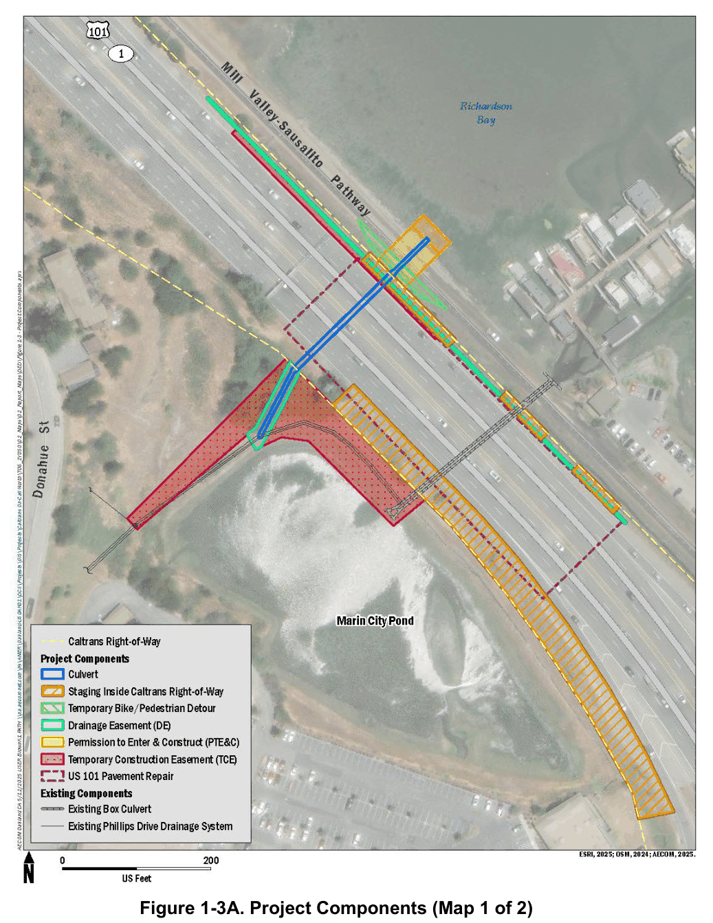
A bypass taking the Phillips Drive hillside drain away from the pond's culvert, through a new 6 ft by 4 ft box under US 101, to an outfall with a duckbill check valve. Modeled to cut the 10-year peak pond level from 7.6 to 7.0 ft NAVD88.
Figure 1-3A · Marin City Second Culvert Project, Draft Initial Study / Mitigated Negative Declaration, p. 1-10Source ↗
June 9, 2025Done
Funding
Army Corps study agreement signed
US Army Corps of Engineers, with Marin City Community Services District
The agreement that starts the study, signed. The Marin City Community Services District, the local elected board, is the official local partner, and the federal government pays 100 percent of the $15 million study and project.
Project location map · Marin City Flood Risk Management Study, Section 205 (CAP), p. 1Source ↗
October 2025Done
Study
Marin City Stormwater Plan 2025 published
Marin County Flood Control District
The umbrella plan: four projects in priority order, the outlet documented, and the pond invert recorded as silted from 0.7 ft to about 3 ft NAVD88. It finds that sponge measures (rain gardens, permeable paving and other ways of soaking rain into the ground instead of piping it away) did little for flood control in the county's model, though it still recommends them for water quality.
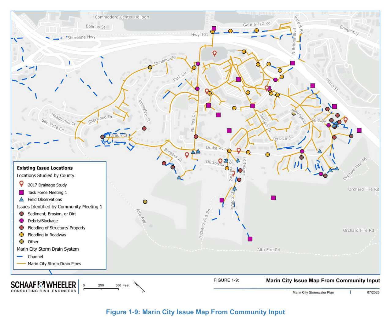
Figure 1-9 · Marin City Stormwater Plan, p. 9Source ↗
November 13, 2025Done
Public meeting
Army Corps planning charrette
US Army Corps of Engineers
The first planning workshop under the Section 205 study.
Reported as the construction year for the Marin City Second Culvert Project.
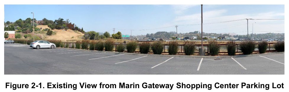
Figure 2-1 · Marin City Second Culvert Project, Draft Initial Study / Mitigated Negative Declaration, p. 2-40Source ↗
December 2027Scheduled, date tentative
Public meeting
Draft report published, and a public meeting
US Army Corps of Engineers
The draft NEPA report released for public and agency review, with a public meeting. This is the comment window: a federal agency must respond in writing to substantive comments on a draft NEPA document, and those responses go on the record.
December 2028 – July 2030Scheduled, date tentative
Construction
Design
US Army Corps of Engineers
The agency calls this date tentative.
September 2030 – January 2031Scheduled, date tentative
Construction
Construction contract procurement
US Army Corps of Engineers
The agency calls this date tentative.
February 2031 – September 2032Scheduled, date tentative
Construction
Construction
US Army Corps of Engineers
The end of the schedule as it currently stands. Fourteen years after the drainage study and the People's Plan each named the problem.
The agency calls this date tentative.
What the first five rows mean
A consequence of where people were permitted to live
Everywhere else on this site, the flooding is about the shape of the land: the low ground around Drake and Donahue drains through a single , and a on it is shut when the bay is high. These five rows say something the land cannot. When the yard closed in 1946, the higher, drier ground across Marin was already closed by deed to the people who had come to build the ships. They were left with the valley floor.
Both facts are matters of record: one measured off federal lidar, the other recorded by the county in its own archive of its own deeds. Together they say the water stands where it does because of the terrain, and that the people standing in it are there for reasons that were written down and signed.
The flat itself is part of the story. Much of the bayside flat in southern Marin is fill: marsh, soft ground and in places the bay itself, filled in and built on. That is the ground the wartime housing went up beside, the pond sits in, and every flood on the rest of this site happens on. Greenbelt Alliance ↗ reports it. We have not yet found a geotechnical map of the fill.
This is why the flooding is not only an engineering question. A drainage problem gets solved when somebody funds a pump. One that lands on a single community, because that was the only place its residents were allowed to live, is also a question of who is owed the pump and how long they have been waiting for it. The first study on this list is from 1992.
What the records show, and what they do not
There is a stronger sentence we could write here, and we will not: that the low ground was chosen for this community. The housing went up next to Marinship in 1942, and Marinship was on the waterfront because that is where you build ships. Nothing we have read shows the 1942 siting was about race, and we will not be the first to say so without evidence.
What the covenants decided was not where the town was put. It was who was still standing on it four years later, once everyone with the option to move to higher and drier ground had taken it. That is the claim the documents support, and it is the harsher of the two. Nobody was assigned to this ground. But leaving it was decided for them.
Reading the list
Four things it shows that no single agency page does
The ideas are old and the construction is new. Almost everything now funded (a second , a pump, a , digging the silt out) appears as a costed item in the January 2018 drainage study, and several appear in the People's Plan the same year. Nothing on this list needed inventing. It needed paying for, and that took six years.
Five parties, one small neighborhood. Army Corps, Caltrans, County flood district, Transportation Authority, the community. Their schedules do not appear on each other's websites. And the community is not just an audience here: the Marin City is the non-federal sponsor of the study, the largest thing on this list.
The far end of the schedule is a long way off. The Army Corps timetable ends with construction running to September 2032, and the Corps labels most of those dates tentative. That is not a criticism of anybody: a federal feasibility study is slow by design. It is a reason to know the dates, because the near ones are where you can still change what gets chosen.
Where a comment lands on the record. The Army Corps expects to release a draft report for public and agency review, with a public meeting, around December 2027. A federal agency must respond in writing to substantive comments on a draft document, and those responses become part of the project record. A measured depth from a photograph is a substantive comment; so is a dated photo of a street the document does not mention. The documents are on the studies page, and every figure on this page is on the pictures page, in full and cited.
Past and coming are worked out against October 27, 2026, the day this page was last built. Dates come from the agencies' own published material and move without notice. Follow the source link on any row before relying on it.